
Brits are forecast a mini heatwave this week with temperatures predicted to hit highs of 22C.
The three-day hot spell will hit areas across the nation according to WXCharts weather maps, which use MetDesk data.
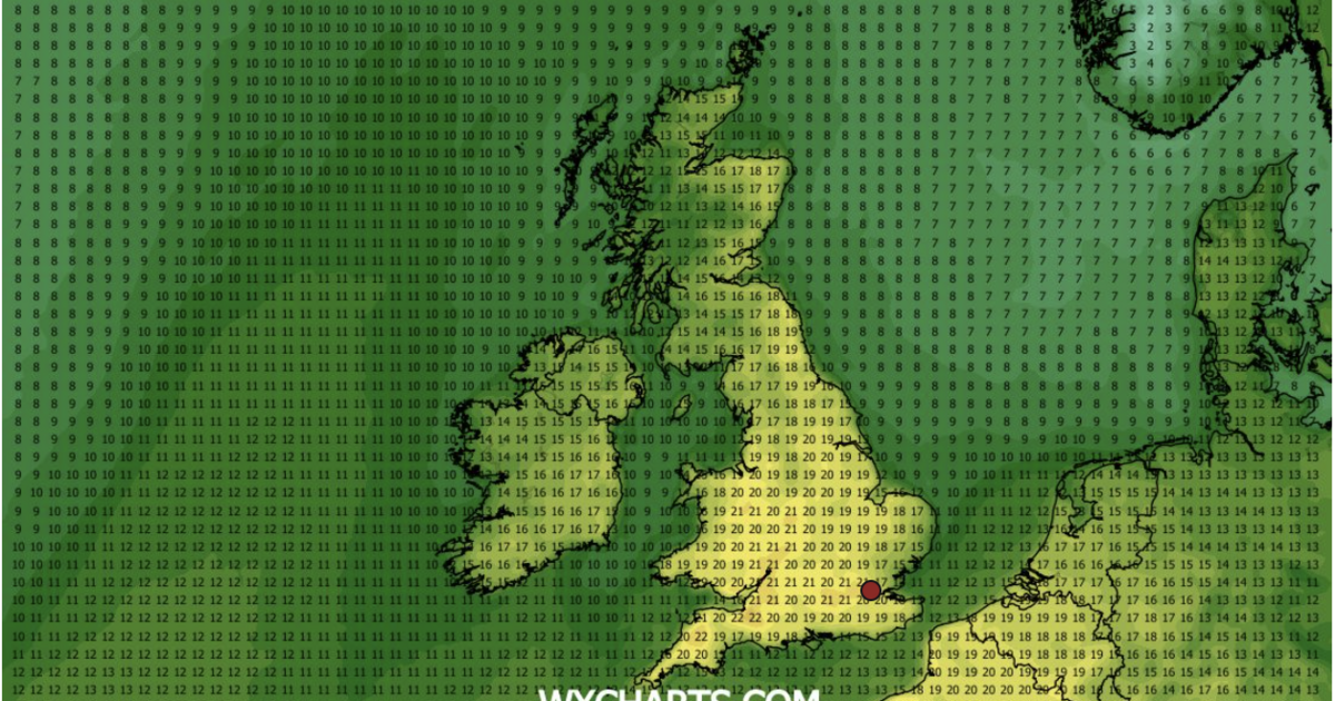
From Tuesday, temperatures will beging to rise as many regions will reach highs of above 20C.
The south west can expect the best sunny spell, as Somerset and Bristol are forecase a whopping 22C according to the maps on Wednesday, April 8.
This mini heatwave hits in the middle of the half term break before dramatically dropping again before the weekend.
A Met Office spokesperson said: “As Storm Dave has now moved away, and this high pressure is building behind it, we’re now dragging up warmer air from the continent.
“It’s one of the seasons where it can change really quickly, day on day.”
On Tuesday, the sun will be shining across a lot of the UK, with regions in the south welcoming a pleasant 18C.
Cities in the north will also hit the high teens with Gloucestershire and Oxfordshire expecting to reach 19C.
Wednesday will be the warmest day across the board according to forecasters.
In the north Cheshire are predicted a toasty day, hitting 20C, warmer than many areas in the south. The capital is also likely to reach 20C.
Across Wales the country is likely to see averages of 19C and 20C as well.
On Thursday, temperatures in some areas start to drop as a slight chill sneaks in. The south west see the end of their heat wave but across England other areas in the south remain in the twenties.
The capital is forecast to hit 20C again with Cambridgeshire and Suffolk also predicted to hit 19C.
According to the Met Office most places across the UK will experience dry conditions with sunny spells, feeling warm in the sunshine.
Just ahead of the weekend a coolness will hit again as temperatures reach an average for this time of year.