
UK weather maps are forecasting a return to warm temperatures in the coming days, with five regions set to be a scorching 22C.
The warmer conditions forecast for midweek come after a period of unsettled and disruptive weather driven by Storm Dave, which has brought heavy rain, strong winds, and travel disruption across parts of the UK and Ireland in recent days.
A shift in the jet stream later this week will allow high pressure to build from the south, bringing a temporary but notable change in conditions.
As Storm Dave clears eastwards, warmer air from continental Europe will push into southern Britain, allowing temperatures to climb into the low 20s.
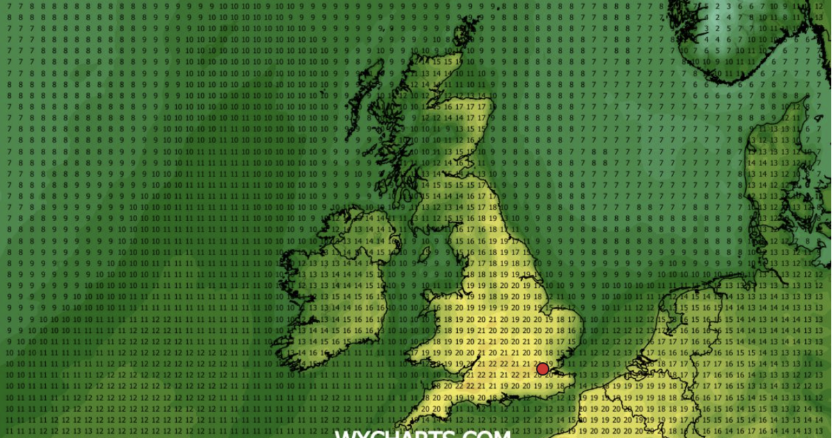
According to WXCharts weather maps, using MetDesk data, parts of the South East to hit 22C on Wednesday, April 8, while huge swathes of England will be 21C.
Other maps show many parts of the UK enjoying hughs of up to 19C from Tuesday, but the peak to the scorching te,peratures will strike on Wednesday at around 6pm.
And many more parts of the UK are will welcome in temperatures of above 20C, according to the maps.
It will come as a welcome break for many, after the Met Office warned that Storm Dave could bring heavy snow and gale-force winds on Sunday.
An amber weather warning for wind came into place for parts of northern England, Scotland and Wales earlier on Saturday, and the Met Office has now said the storm will "continue to deepen".
Heavy snow and gale-force winds will also bring disruption, with winds of up to 66mph already being recorded in Capel Curig, north Wales.
Parts of Lancashire, North Yorkshire, Northumberland, north Wales and Scotland are covered by the amber warning, which came into effect at 7pm and is due to remain in place until 3am on Sunday.
An alert for wind covering northern England, parts of Scotland and part of Wales is active until 7am Sunday.