
Despite temperatures rocketing across the UK today, icy conditions and snow appear to be imminent for many.
Advanced weather forecasting maps indicate snow could descend for eight consecutive days later this month as major cities, including London, welcome some of the white stuff.
The snowstorms are anticipated to commence on March 13, as the ECMWF weather model displays sparse pockets of snow developing over Scotland, northern England and parts of the south-west.
An Atlantic weather front appears set to sweep in on March 14, with snow depicted falling in Northern Ireland, southern Scotland and northern England whilst heavy rain strikes the rest of England and Wales.
The maps reveal yet more snow arriving on March 15, again restricted to northern regions. Cities including Glasgow, Edinburgh and Newcastle could witness some flurries at around 6am.
Across March 16 and 17, the data illustrates light snow descending over hills in Scotland. Some wintry showers could also affect South Wales and the south-west of England at around midday on March 17.
That snow is then expected to drift eastwards. Maps for 6am on March 18 astonishingly show snow affecting southern England and London.
On March 19 and 20 more of the white stuff looks set to impact Northern Ireland, northern England and Scotland - rounding off eight consecutive days of snowfall.
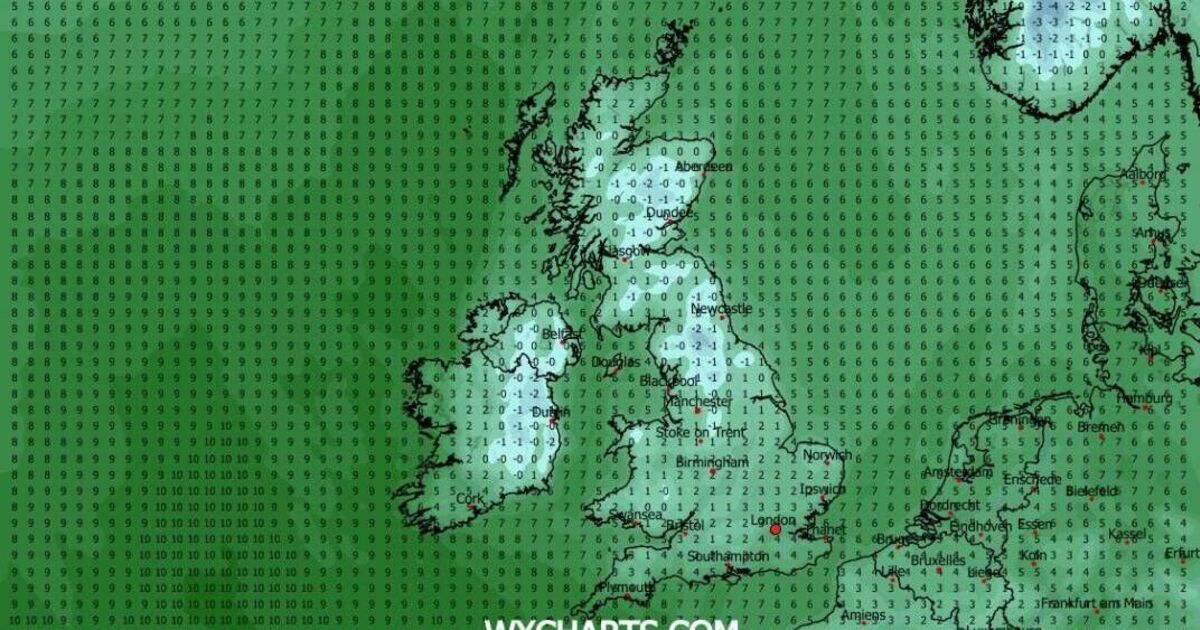
Temperatures are predicted to plunge below freezing at times throughout this period, according to the maps. On 18 March, the mercury could plummet as low as -2C in northern England and Scotland.
Even in southern England, daytime temperatures may struggle to rise much above 4C.
The Met Office warns that "wintry hazards" could affect the UK later this month. However, the national weather agency does not anticipate "really cold" conditions.
The Met Office forecast for 19 March to 2 April states: "The start of this period could see unsettled conditions quite widely across the UK, with spells of rain and strong winds affecting many areas at times.
"Then, whilst confidence in the details is low, there is the potential for weather patterns to become slower-moving by late March, with unsettled weather becoming more confined to parts of the south, as areas towards the north and northwest turn drier. Given this pattern, the chance of wintry hazards will increase compared to earlier in March.
"Overall, temperatures will probably end up near to average, but there is an increasing chance of below average temperatures towards the end of March, though at present, there is no strong sign for any really cold weather to develop."