
The UK is bracing for a month's worth of rain to fall in just a few hours today, sparking fears of widespread flooding and travel chaos.
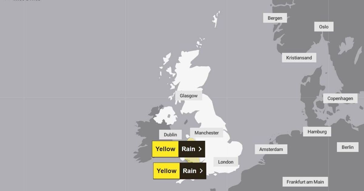
Two yellow weather warnings have been issued as torrential downpours are expected to sweep eastwards throughout the day. The worst-hit areas, including various locations across Wales, could see up to 70mm of rain in a short period, leading to potential flooding , travel disruption and power cuts.
Typically, communities in southwest Wales, such as Swansea, experience around 75mm to 80mm of rain in an average September. However, Swansea and surrounding areas, including Merthyr Tydfil and Llandeilo near the Brecon Beacons National Park, are subject to one of the weather warnings today.
This means that the impending downpours could equate to nearly an average September's rainfall, prompting communities to prepare for the worst.
While the other weather warning concerns parts of north Wales, heavy rain is also expected across parts of the Midlands today. The Met Office has warned that travel delays and flooding are most likely across Gwynedd, including most of Snowdonia National Park, reports the Mirror.
According to data from Current Results, Harlech in Gwynedd typically experiences 80mm of rain across the entirety of a standard September. The forecasted 60mm peaks across north Wales today, although less than parts of the south, still pose a significant risk of flooding and the possibility that communities could be cut off.
"Heavy rain may lead to some travel delays and flooding in a few places during Wednesday. Rain will become persistent and at times heavy across south and southwest Wales during Wednesday morning and is likely to continue for much of the day. 30-40 mm of rain is expected to fall widely with some places, chiefly on south-west facing hills, receiving 50-70 mm," the weather warning on the Met Office's website reads.
"Flooding of a few homes and businesses is possible. Spray and flooding on roads will probably making journey times longer. Bus and train services [will] probably be affected with journey times taking longer. There is a chance of some interruption to power supplies and other services."
Torrential downpours are set to batter the Midlands as well, with Staffordshire and the Birmingham area bearing the brunt.
The deluge will gradually shift eastwards before turning showery across the East of England come afternoon.
Whilst the Midlands hasn't yet been slapped with a weather warning, Birmingham typically experiences just 68mm of rainfall throughout the entire month of September.
The worst of the downpour is expected to strike during the morning commute, forecasters fear.
This follows relentless showers that have already soaked the Midlands earlier this week. Flood alerts have been issued for several areas, including a warning for the River Greta and River Derwent in Cumbria, where numerous campsites near Keswick could be affected.
There are also concerns, albeit to a lesser extent, for the Exmoor Rivers in Devon and the Upper River Tamar, which forms the border between Devon and Cornwall.
Natural Resources Wales has also issued several flood alerts, particularly in areas subject to weather warnings. There is significant concern for rivers in the upper Towy catchment upstream of Llandeilo, Carmarthenshire, as well as rivers in Llanelli and the neighbouring areas of Llangennech, Pwll and Burry Port.