
Britain appears poised to endure a widespread deluge in just a matter of days, with no corner of the nation escaping the torrential downpours.
Based on GFS weather model charts, precipitation is forecast to sweep in on Saturday, September 13, soaking regions from the South East of England to Scotland's northern reaches - covering approximately 600 miles.
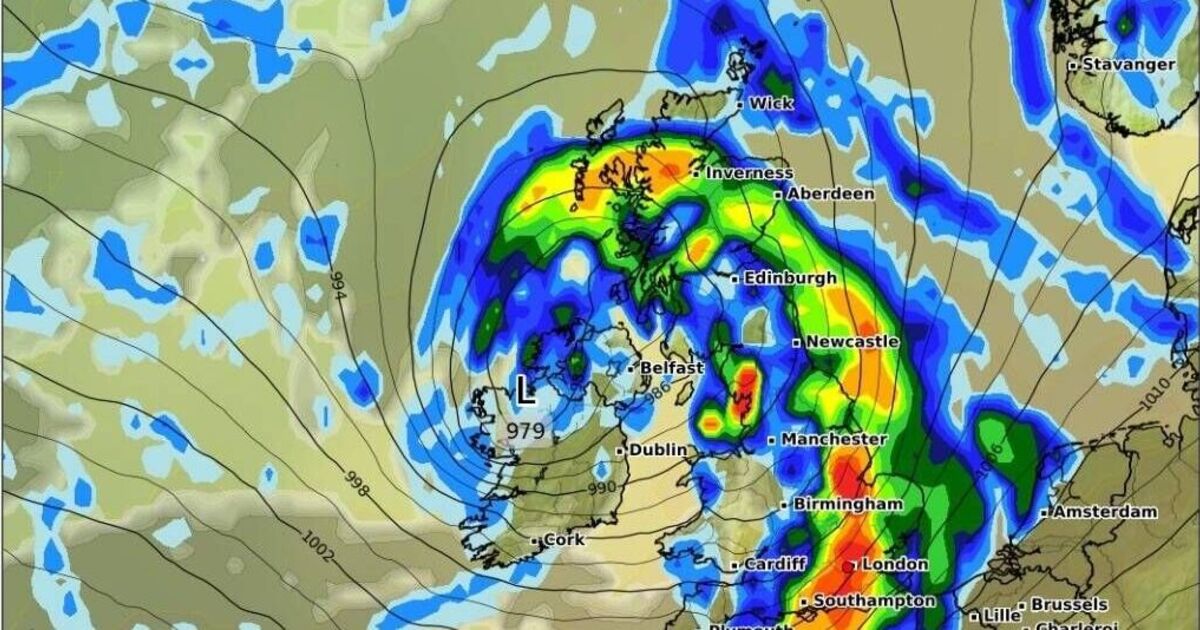
Locations in the path include London, Kent, Essex and Southampton, alongside Birmingham, Manchester and Newcastle further north. The news comes after this UK weather maps show exact time 520-mile storm stretches from Aberdeen to Southampton.
Across Scotland, Inverness and Aberdeen are amongst the cities preparing for persistent deluges whilst Belfast and neighbouring areas in Northern Ireland also appear destined for a drenching.
The charts suggest precipitation will be most intense across portions of southern and eastern England, with London, Southampton, Peterborough, Norfolk and Lincolnshire forecast to experience between three and five millimetres per hour, reports the Mirror.
Inverness is also anticipated to endure downpours of approximately three millimetres hourly, whilst much of the remaining UK will witness lighter precipitation ranging from 0.2 to one millimetre per hour.
This follows the Met Office's warning that low pressure systems will control the second week of September, delivering showers, extended periods of rain, and the possibility of thunderstorms, hail and powerful winds.
In its extended forecast from September 9 until September 18, the weather service stated: "Much of this period will be unsettled, with low pressure likely to dominate the overall pattern. This will mean showers or longer spells of rain will affect much of the UK at times.
"Some heavy rain or showers are expected in places, most often in the west and north. Thunderstorms and hail are also possible, as are some spells of strong winds, especially if any deep areas of low pressure develop and affect the UK.
"Later in the period, there may be some longer spells of drier weather that develop, especially towards the south, with more in the way of sunshine due to higher pressure here. Temperatures will likely be close to average or slightly below overall, but may rise above at times in any drier, sunnier spells."
BBC Weather's forecast for 8th to 14th September reads: "The first half of next week should remain unsettled, with more rain or showers expected as further low pressure and frontal systems arrive from the west.
"There could once again be some isolated thunderstorms and locally heavy rain, and temperatures will ease, most likely fluctuating just above the September average, though no significant cool-down is anticipated.
"Some strong and gusty winds could be on the cards at times as the rain comes and goes, but a calmer and drier couple of days is possible in the second half of the week as transient high pressure ridges potentially cross the UK.
"However, further rain or showers could be in the offing by the end of the week, with high pressure not fully taking hold. The northern and western UK may be wetter than southern and eastern regions. Temperatures should stay variable but, on average, ought to be a little above the seasonal norm."